SOUTHWEST ENERGY HIGHLIGHTS
SouthWest Energy is the first and only local Ethiopian company to successfully obtain an energy concession in Ethiopia.
SouthWest Energy's initial focus is on the Ogaden Basin, the largest proven hydrocarbon basin in Ethiopia, with 3Tcf proved reserves.
SouthWest Energy has secured blocks 9, 9A and 13 in Ethiopia's Ogaden Basin. These blocks cover 29,000 square kilometers in an ‘oil prone’ part of Ogaden Basin. The initial PSA agreement was signed in December 2005.
- These blocks have a high prospectivity for oil rather than gas due to a shallower burial depth which makes it possible that potential Karoo age source rocks are still in the oil window.
- Recent reprocessing and reinterpretation of 2D seismic covering 15% of blocks 9 and 13 yielded at least 16 prospects and leads, including two prospects with over 500 million BOE recoverable unrisked.
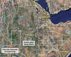
As part of its continuing development strategy SouthWest has agreed in principle to a joint study of one of the more prospective Rift Valley plays with the Ministry of Mines and Energy. This 60,000 square kilometer block is know as the Jimma block and is located in south central Ethiopia. The study agreement will give SouthWest right of first refusal over this acreage.
The original Petronas led multi year study of the Ogaden basin resulted in Petronas acquiring 8 blocks. Petronas has signed a deal committing USD3 billion to gas development activities in the Ogaden Basin.
Potentially attractive economics based on the terms of the Production Sharing Agreement (‘PSA’) SouthWest Energy has entered into with the Government of Ethiopia and potentially low drilling costs (USD10 - 12 million/well) relative to prospectivity (large structures).
SouthWest Energy has concentrated on putting together a strong management team with extensive regional and industry experience and key government and industry relationships. Care has been taken in developing the management team to ensure that there is a good technical development parallel to good financial discipline.
OGADEN BASIN OVERVIEW
The Ogaden Basin covers 350,000 sq km and is the largest proven hydrocarbon bearing sedimentary basin in Ethiopia. There are two large gas discoveries in the basin which contain estimated reserves of approximately 3Tcf (Calub and Hillala).
The Ogaden Basin was recently subjected to an exclusive Basin-wide joint study by Petronas with the Ethiopian Ministry of Mines. The 22-month joint study concluded in April 2005, and Petronas subsequently sought to license a majority of the 22 exploration blocks in the Ogaden Basin. The Ministry of Mines decided to award a portion of the blocks to parties other than Petronas (which was limited to 8 blocks) in order to encourage competition.
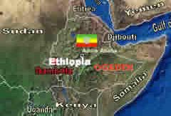
As the only indigenous energy company in Ethiopia, SouthWest Energy capitalized on its strong relationship with the Ministry of Mines in order to secure blocks 9, 9A and 13. Petronas (which is pursuing a gas strategy), concluded these blocks were more likely to be oil prone. SouthWest Energy's blocks cover a total area of approximately 29,000 square km in the northeast part of the Ogaden Basin.
ETHIOPIA IN BRIEF
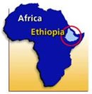
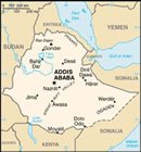

The Federal Democratic Republic of Ethiopia has been a democracy since the 1991 abdication of Mengistu Haile Mariam's Communist government.
The headquarters of the African Union (formerly the Organisation of African Unity) has been in Ethiopia since 1964, making Addis Ababa the capital of Africa.
Active government commitment to encourage greater foreign direct investment to improve Ethiopia's low GDP per capita (estimated at approximately USD900 in 2005).
BROADER REGION HAS PROVEN OIL POTENTIAL(1)
| Sudan 1.6
billion BOE of reserves and ongoing exploration activity by CNPC, ONGC,
Petronas and White Nile. Uganda underexplored but first oil discoveries recently made in rift system at Lake Albert by Tullow and Hardman. |
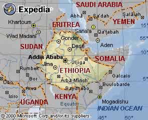 |
Yemen 4
billion BOE of recoverable reserves. Somalia exploration by ENI, Amoco, Chevron and Conoco pre-empted by force majeur declaration after government's collapse. |
Of the countries within close proximity to Ethiopia, only Yemen, Saudi Arabia and Sudan have been actively explored.
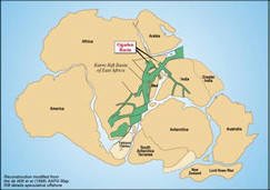
There has been a surge in exploration interest throughout the East African region based on a growing consensus about the potential for a major regional hydrocarbon system referred to as the East African Rift System (also know as ‘Karoo’ sedimentary horizon).
(1) Sources: www.cia.gov and www.mbendi.com.
KAROO RIFT SYSTEM IS AN EMERGING REGIONAL PLAY
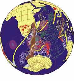
The regional tectonic history of East Africa traces back to the supercontinent of Gondwana, which included most of the landmasses in today's southern hemisphere, including Antarctica, South America, Africa, Madagascar, Australia-New Guinea and New Zealand, as well as Arabia and India from the Northern Hemisphere
The rift basins of East Africa are predominantly filled with continental sediments called the Karoo, and the primary trend extends from South Africa to Ethiopia in the Northwest and India in the Northeast.
At least 10 billion barrels of recoverable oil have been discovered onshore in Madagascar at the Southern part of this trend.
Exploration activity in the Southern Karoo (Mozambique, Tanzania and Madagascar) has heightened dramatically with the recent entry of Exxon, Petrobras, Norsk Hydro, Anadarko and Chevron, among others.
ETHIOPIAN POTENTIAL
It is believed by the Ethiopian Ministry of Mines and the Petronas Joint Study that the two most promising hydrocarbon areas in Ethiopia are the Gambella Basin (in the southwest bordering Sudan) and the Ogaden Basin (in the southeast).
The Gambella Basin is believed to be geologically analogous to south-eastern Sudan. In June 2003, Petronas invested approximately USD100 million to explore the Gambella Basin, with exploration activities ongoing. (Ministry of Mines & Energy).
The Ogaden Basin represents the ‘western half’ of the Ogaden/East African Karoo rift basin, with the Morondava Basin in Madagascar representing the ‘eastern half’. According to various market sources, the Morondava Basin contains at least 10 billion barrels of oil in the Bemolanga tar sands and Tsimiroro heavy oilfield, although the country remains largely unexplored.
OGADEN BASIN HYDROCARBON PROSPECTIVITY
In addition to the Calub (2.7Tcf) Hillala gas (0.3Tcf) discoveries near the center of the basin there have also been numerous oil shows in more than 20 exploration wells.
Petronas has successfully negotiated a USD3 billion, 25 year, gas development project for Calub and Hillala in the Ogaden Basin. The project involves a significant infrastructure buildout that includes export pipelines. The deal signals a high confidence level in the probability of finding significant additional gas reserves, since the economics of the initial 3Tcf commercialization would not likely justify a standalone development.
There have been no wells drilled on SouthWest Energy's blocks. The first successful well drilled should increase the blocks' value.
JIMMA JOINT STUDY AREA
Work is about to start on this new play with SouthWest currently negotiating the dimensions of the study program.
The area is know to contain petrolierous geology with the thermocline required for maturation being provided either by burial or by the tertiary rifting known to occur in the area.
The area will be the subject of a one year joint study with the Ministry of Mines and Energy, which will review the known geology and look at possible gravity and magnetic studies prior to any further geophysical studies.
OGADEN BASIN COMMERCIALIZATION OPTIONS
Ethiopia has over 77 million people and a developed road system for trucking small scale production (up to 9,000 barrels a day), making it a viable market for local hydrocarbon consumption. Excess capacity can be exported via pipeline to either Djibouti or Berbera.
SouthWest Energy's PSA provides that SouthWest Energy will be paid international market prices for its production (based on a market weighted average price), even for local sales in Ethiopia.
Petronas' gas development plans include building a gas pipeline through SouthWest Energy's blocks 9, 9A and 13, allowing SouthWest Energy the potential to tie into Petronas' gas pipeline.
If there is a commercial discovery in the Ogaden Basin, there is a possibility (after discussions with the Ethiopian Government) of building a refinery close to Addis Ababa, as well as the Government building a pipeline to either Djibouti or Berbera.
The SouthWest blocks with their potential for both oil and gas are ideally placed to take advantage of both cases.
PETROLEUM SYSTEMS CHART OF THE OGADEN BASIN
Main Reservoir Calub and Adigrat Sandstones.
Main Source Bokh shale.
HYDROCARBON POTENTIAL SUMMARY - BLOCKS 9, 9A AND 13
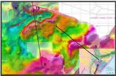
Gravity, Aeromag and seismic data (acquired in 1992) has identified the presence of a rift system in northeastern Ogaden Basin. (Maxus)
A petroleum system study of the Ogaden basin has concluded that this newly identified rift system, east of the Marda Fault Zone, is of Permo-Triassic, Karoo age. (Petronas / Ministry Joint Study)
The Karoo is a prolific petroleum system in East Africa with billions of barrels of oil discovered in Madagascar, several Tcf of gas condensate in the Ogaden basin, and a large number o hydrocarbon shows all along the East African coastal basins.
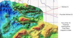
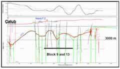
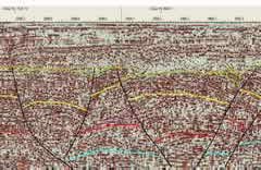
Numerous structural traps were identified on block 9, 9A and 13 with two of which show potential recoverable resources of over 500 million BOE, based only on the current 2D seismic (covers less than 15% of the blocks).
SouthWest Energy Hydrocarbon Prospectivity
The Gravity re-processing shows two potential hydrocarbon kitchens. The main area of interest, area A, is interpreted at below 7000, confirmed by the legacy seismic data, well below both oil and gas window depth requirements for the known geology. The basin in block 9A, possible kitchen B, needs more exploration to define both shape and depth, as it lies close to surface mapped tertiary basalts. The traps are based on faults seen on both gravity and seismic section.THE KAROO PETROLEUM SYSTEM
Triassic to Early Jurassic Adigrat Formation.
- Various facies from high ash coals through variably carbonaceous mudstones/siltstones.
- Complex association of fluvial-alluvial-delta and delta front environments associated with a major transgression.
Triassic Bokh Formation Shales.
- Probable lacustrine facies associated with the main rift phase in the Karroo sequence.
- Deep water anoxic layer in lake.
EVIDENCE FOR EXTENSION OF KAROO RIFTING IN NORTHEASTERN OGADEN
HYDROCARBON POTENTIAL SUMMARY BLOCKS 9, 9A & 13 – DEPTH TO BASEMENT FROM GRAVITY
In addition to proving the continuation of Karoo rifting north of the Marda fault zone, due to a shallower burial depth, attributed to the lack of Jurassic and Cretaceous age rifting episodes in the region, it is expected that Karoo age potential source rocks would still be in the oil window in Northeastern Ogaden Basin where blocks 9, 9A and 13 are located.
ANALOGOUS PERMO-TRIASSIC PETROLEUM SYSTEM
Madagascar - Morondava BasinA proven Permo-Triassic petroleum system
|
Ethiopia - Ogaden BasinProven Petroleum System with 2.7 Tcf gas and condensate discovery
|
REGIONAL TECTONIC HISTORY RELATED TO THREE RIFTING EPISODES, LINKED TO THE BREAK-UP OF GONDWANA
- Permo-Triassic (Karoo)
- Fragmentation of Africa / Madagascar / Indo-Australian blocks
- Initiation of the Indian Ocean
- Upper Jurassic - Cretaceous
- Progressive opening of Indian Ocean
- Rifting along the Central African Shear Zone
- Teriary
- Break-up of Afro-Arabian plate
- Opening of Red Sea and Gulf of Aden
- Development of East African rift system
SATELLITE MAP WITH SEISMIC COVERAGE
SEISMIC EXAMPLE ACROSS THE AREA SHOWING ERODED RIFT SECTION BELOW THE UNCONFORMITY
SOURCE:
http://www.sw-oil-gas.com/ogaden_basin_overview.htm


