Project Overview
Source: AFRICA OIL CORP. [Ex-CANMEX]

Pursuant to Venture Agreements entered into by Africa Oil Corp. and Range
Resources Limited on March 4, 2007, Africa Oil Corp. has acquired an 80%
participating interest in the licenses and operatorship of the Nogal and Dharoor
projects, in consideration for a financial commitment, over a six year period,
of approximately US$50 million in exploration expenditures and the payment to
Range of an additional US$3.5 million upon commencement of commercial
production.
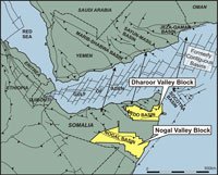
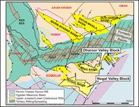
The Nogal and Dharoor basins are considered world-class exploration plays
with a petroleum system geologically similar to and formerly contiguous with
those within the Republic of Yemen.
A comprehensive exploration work program is proposed in respect of each
exploration area commencing in 2007.
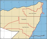
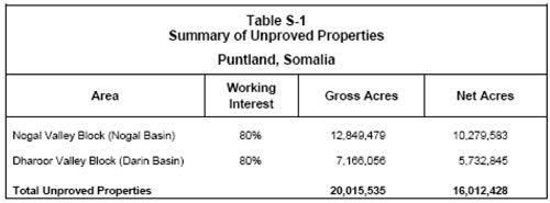
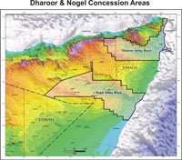
Nogal and Dharoor Valley Blocks
General Overview
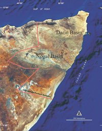
The Nogal Valley and Dharoor Valley Blocks situated in northern Somalia cover
the Nogal Basin and the Darin Basin, respectively.
Combined, the two blocks cover a very large area, with the Nogal Valley Block
extending over approximately 12,849,479 acres, which encompasses the Nogal
Basin. The Dharoor Valley Block extends over an area of 7,166,056 acres,
encompassing the entire Darin Basin. These areas are very large and, with only 5
wells drilled, the area remains one of the least explored areas in North Africa.
The Company with their partners Range Resources Limited signed two Production
Sharing Agreements (PSA) with the Government of Puntland on January 17th 2007.
One covering the Nogal Basin referred to as the Nogal Valley Block and the
second covering the Darin Basin referred to as the Dharoor Valley Block. The
terms and articles of both agreements are identical as are the value of the work
commitments for the exploration phase.
The Nogal Basin covered by the Nogal Valley Block has been identified as having
reservoir, source rock and trap potential. International oil and gas companies
conducted exploration in the late 1980's in the region. During this exploration
phase, a grid of 2D seismic was shot perpendicular to the axis of the rift
system in the Nogal Basin. Based on interpreted maps this data shows a number of
large, closed, fault-controlled structures.
In addition, surface geology identified a number of oil seeps along the main
basin-bounding faults. Several wells drilled on the identified structures
encountered numerous oil shows, however, the wells Nogal-1 and Kalis-1 did not
reach the main exploration target.
Geological Review
 The most clearly defined basins in Puntland are the Nogal and Darin basins.
These large depressions are visible on satellite imagery. The two basins are
believed to be part of a failed rift system and are analogous to the prolific
Yemen rift system found across the Gulf of Aden. It is thought that the oil
reserves found in the Cretaceous and Jurassic sedimentary sequence in Yemen
could also be present in similar formations in the northern portion of Somalia,
since these two areas were joined approximately 18 million years ago, before the
movement of the Indian plate away from the African plate. The most clearly defined basins in Puntland are the Nogal and Darin basins.
These large depressions are visible on satellite imagery. The two basins are
believed to be part of a failed rift system and are analogous to the prolific
Yemen rift system found across the Gulf of Aden. It is thought that the oil
reserves found in the Cretaceous and Jurassic sedimentary sequence in Yemen
could also be present in similar formations in the northern portion of Somalia,
since these two areas were joined approximately 18 million years ago, before the
movement of the Indian plate away from the African plate.
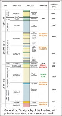
The basin fill is extremely thick, with more than 10,000 feet of sediments in
some areas. The main target reservoir is the Jurassic-aged sandstones belonging
to the Gabredarre Formation. These reservoir sandstones overlie the organic rich
shales and marls of the Uarandab Formation, which is thought to be the source
rock for the oil seeps observed along the boundary faults. The secondary
reservoirs include the deep marine sandstones and shallow marine carbonates
belonging to the Upper Cretaceous Gumburo Formation. The marine sandstones of
the Jesomma Formation, also Upper Cretaceous in age, are also potential
secondary targets. The Jesomma and Gumburo have isopach thicknesses of
approximately 1,350 and 2,450 feet, respectively.
The limited information indicates that reservoir quality rocks are present
within the Nogal Basin. Of the five wells drilled in the Nogal Basin, images of
partial well logs are available for two wells (Nogal 1 and Kalis-1). The
drilling reports for these two wells indicated that the Jurassic sandstone
targets were not reached but that oil shows were found in some of the shallower
sandstones. Nogal --1 was drilled to a depth of 10,736 feet in 1990. Kalis-1 was
drilled to at least a depth of 5100 feet in 1990 according to log images. The
original plan for Kalis-1 was to drill it to a depth of 14,850 feet.
Surface seeps of oil, as well as oil shows reported in several exploration wells
drilled by previous operators in the area, indicate that the source rocks have
generated hydrocarbons and that they have migrated through the system. There is
not enough data yet to determine if trap formation predates hydrocarbon
migration, however.
The indications from the limited number of wells drilled in the basin are that
the basin appears to be oil-prone.
Seismic structure maps prepared in the late 1980's by a major oil company and
obtained from the Somali Government by the Company show that a number of
fault-bounded structures with three way dip closures do exist within the basin.
A seismic base map for the basin indicates that approximately 2500 line miles of
2D seismic has been shot representing some 76 seismic lines.
A review of three seismic lines show good structuring in the subsurface with
evidence of tilted fault blocks and rollover closure. The structures identified
by the major oil company using the seismic data, appear to be quite large with
some in excess of 4,000 acres and as large as 14,000 acres. These, combined with
the extremely thick section of basin fill, provide multiple horizons in which
hydrocarbons can be trapped.
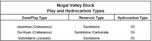
The following table indicates the zone / play types considered for the Nogal
Valley Block.
There is insufficient data available at this time for the Dharoor Valley Block
to assess the potential within the Darin Basin. The size and proximity to the
Nogal Basin suggest that it has had a similar geologic history and, as such,
should have similar prospectivity to the Nogal Basin. Future exploration will be
needed in order to assess this large area to determine its potential.
Work Programs
A comprehensive seismic reprocessing program, including review and
integration of all geophysical and geological data, has been successfully
completed on the Nogal Block.
The Company has entered into a contract for a drilling rig to begin drilling in
our Puntland concessions during 2008. The contract effective date is February
19th, 2008 and covers the drilling of two wells with a two well option. It is a
standard day rate contract and was negotiated at competitive rates. The first
well is expected to spud in July 2008.
A drill program is also being planned for the Dharoor Block to follow the drill
campaign at Nogal. The Company is scheduling a major seismic acquisition program
over the Dharoor area and expects a seismic crew to be mobilized in early 2008.
Somalia Concessions
Operations Update
February 2008
The Company has entered into a contract for a drilling rig to begin drilling in
our Puntland concessions during 2008. The contract effective date is February
19th, 2008 and covers the drilling of two wells with a two well option. It is a
standard day rate contract and was negotiated at competitive rates. Drilling
will begin before the commencement deadline date of August 1st, 2008.
The contract was signed with Energi Tata Persada Pte Ltd (ETP), a Singaporean
registered company. ETP is a wholly owned subsidiary of Catur Khita Persada, an
Indonesian oil and gas service company. They own four land drilling rigs and
perform extensive turn key drilling projects in Indonesia. ETP have employed
Roger Boyco to manage the Puntland project. He has over 30 years experience
managing land drilling projects around the world.
The ETP rig No 3 is a brand new package currently being constructed in the
Shengli fabrication plant in Dongying, China. Shengli currently have nine
drilling units under construction for international drilling contractors. The
ETP rig is scheduled for delivery in mid May, 2008 and will immediately mobilize
to Jebel Ali, Dubai. The mobilization into Somalia will be via chartered vessel
and the current plan is to spud the first well during July.
The ETP No 3 is a 1,500 HP unit, equipped with the latest drilling technology,
including a top drive and three 1,600 HP pumps. The camp facility will house up
to 150 persons and will also be brand new. ETP will also provide the trucking
and hoisting equipment as part of their contractual obligations.
March 2008
Mobilization of casing and camp construction equipment is underway in
preparation for spudding the first of an initial two well program on the Nogal
Block in Puntland, Somalia. The equipment is currently in Djibouti and is
anticipated to arrive in Somalia within the next week. The first well is
expected to spud in July, 2008.
The Company has farmed into an 80% interest in the Nogal and Dharoor blocks. The
concessions encompass two highly prospective hydrocarbon basins and cover an
area of 81,000 square kilometres or more than 20 million acres.
The two sedimentary basins were contiguous with the prolific Marib and Masila
basins in Yemen during the Jurassic and Cretaceous periods. Over 9 billion BOE
have been discovered in Yemen but exploration has been limited to date in
Somalia. Only 3 wells have been drilled in basinal settings in these concessions
before operations ceased in the early 1990's. Those wells confirmed thick
sedimentary sequences, encountered oil in Cretaceous sandstones and proved the
presence of active petroleum systems in both basins.
In the Nogal Basin, Africa Oil has acquired all of the more than 4,000
kilometres of good quality 2D data which was recorded in the late 1980's. This
has enabled the Company to work up an inventory of drilling prospects from which
the first two well locations will be selected.
At the Dharoor Block, the Company has finalised a contract for shooting
approximately 2,600 kilometres of 2D seismic. The seismic crew is expected to be
on the ground in Puntland by the end of April, 2008.
Resources/Reserves
Assessment of the Undiscovered Resources Associated
with the Nogal Valley and Dharoor Valley Blocks
Puntland, Somalia
(As of January 31, 2007)
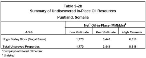
The following estimate of undiscovered in-place oil resources was prepared
during January and February 2007, by qualified evaluators and auditors of
Sproule International Limited ("Sproule").
Africa Oil Corp. holds an 80 percent in the Nogal Valley and Dharoor Valley
blocks, which have been configured to encompass the Nogal and Darin sedimentary
basins respectively.
Using data provided by Africa Oil Corp., data available in the public domain and
from the nonconfidential files of Sproule, an assessment was made of the
undiscovered oil resources of the Nogal Valley Block. At the time this report
was prepared, Sproule was unable to make an assessment of the undiscovered
resources associated with the Dharoor Valley Block (Darin Basin) due to a lack
of data.
The Darin and Nogal sedimentary basins are thought to have very similar
geological histories and, as such, it is surmised that the undiscovered
resources associated with the Dharoor Valley Block might be similar to that of
the Nogal Valley Block.
The estimates for the Nogal Valley Block are based on a probabilistic model of
the expected reservoir parameters of prospective reservoirs and traps that may
be encountered within the block. The reservoir parameters of porosity, water
saturation, pay thickness, area and formation volume factors were selected based
on the available data and are considered to represent the range of possible
values that may be encountered by future exploration wells.
As no commercial discoveries have been made on either of the blocks as of the
effective date of this report, no proved, probable or possible reserves have
been assigned to the blocks at this time and the lands have been assessed as
unproved properties.
Full Technical Assessment of
the Undiscovered Resources Associated with the Nogal Valley and Dharoor Valley
Blocks
Source: AFRICA OIL CORP. [Ex-CANMEX]
|